Saturday, October 21, 2017

Interpreting my Bad Resources

In the last post I did a guesstimate calculation for Tinka's South Ayawilca deposit, and I've received a few e-mails about how to interpret this data.


I also have 2 tables.


Occasionally, I make some excel errors, if you find some, please send me some abusive e-mails!


Tinka Update

I'm going to do a different spin on the post, initially focusing on the results and then look at some areas that have been under-drilled to see where Tinka can go to add some tonnes to and/or improve the quality (category) of their resources.

Summary

  • Some good infill holes (A17-085 and 096) in the core of the system
  • System is getting weaker to the east (A17-093) and to the SE (A17-094).
  • Narrow, albeit high-grade zones drilled to the east of the West Ayawilca resource (A17-083 and 085)
  • A few holes were drilled in the Chaucha, Zone 3 and Valley targets, but to date, no significant mineralization was discovered. However, early days.... 

Results

We are now looking at a mature exploration project. Tinka are now drilling the periphery of the South Ayawilca system, so the mineralization is now narrow and deep.

Blue = Sept PR; Red = Oct 2nd PR; yellow = result pending

Here are some sections

Hole A17-087 - SW end of the South Ayawilca Deposit
We can see that mineralization is dying out to the SW.


A17-071 (left) SE extent of mineralization


Mineralization dying out to the NE, but there are a few gaps. Hole A15-041 (to the right) hit multiple zones of moderate zinc mineralization.

The effect that this drilling has had on my officially bad resources is:

Full breakdown of ZnEq resources
We actually see just a slight increase in tonnes, but a decrease in grade. This is due to the slightly lower average grade due to all of the different cut-off limits.

This may sound negative, but essentially Tinka have been drilling at South Ayawilca all year, and have defined a new, deposit at Ayawilca. It will be interesting to see when a new technical report is released.

Opportunities

However, I have a question: Where are Tinka going to drill now? The drilling to date seems to have closed off the South Ayawilca deposit, where are they going to generate future intercepts and grow the resource.

There are 3 areas where they can focus:
  1. Infill drilling - designed to increase the confidence of the resource (increase the amount of M&I resources and reduce the amount of Inferred)
  2. Expansion - drill around the edges and between known mineralized zones.
  3. Green-fields - drilling of new targets
Each of these have a different risk vs reward levels, and I've spent a few days compiling as much of the drilling data as possible from technical reports and old press releases.

They have already started drilling some of the pother regional targets, but unfortunately, so far the results haven't been very positive, but we need to remember that they have only drilled 6-7 holes on them, so it is early days.

So, I will focus on the first two. Where are there: 
  • Under-drilled areas
  • Where some intercepts haven't been followed up on.
NOTE: there may be reasons certain areas haven't been explored (e.g. access issues, topography, hydrology etc.). I'm going to ignore these in this post as I'm not intimately familiar with the project.  

Unfortunately, I'm lazy. Fortunately, Leapfrog can all of the hard work for me. I drew a slice through the project, along the main zinc horizon.


I got leapfrog to create 50m and 100m (radii) buffers around each drill-hole.

Pink = under explored areas
I always do this as it shows me very quickly where there are un- and under-explored areas of a project, and as a simple geologist, I like to put holes in areas where they have a good change of getting high-grade zinc mineralization, like here:


Gaaaaaaapppp

That area is ripe for reaming. This is a perfect area for dumb exploration, simply whack a hole between 'em and you have an easy win! The area to the right of hole A12-008 could also do with a few holes as well, you'll get some decent grades for your PRs there.

However, this raises and interesting question for Tinka. Do they focus on drilling the known mineralization or start exploring the property for more deposits?

If they focus on drilling to improve the confidence in future resource calculations or keep looking for new deposits, and maybe even the BMF?


Thursday, October 19, 2017

Solgold Leapfrog project

I've received a few e-mails from people asking for the full Leapfrog project for Cascabel.

To open the project you need to have the saltest version of leapfrog Geo. You can download an evaluation copy from here - link

You can download the full Leapfrog project from here - link (145MB)

You can download the source drill-hole and surface contour data from here - link (10.8Mb)

I've also created a Leapfrog View containing all of the data I used - link (29.8Mb)

The viewer file can be open using the FREE Leapfrog Viewer program that can be downloaded from here - link

For anyone interested in Leapfrog, I'm working on compiling the Paca project data (as it has everything) into a training data set.

Thursday, October 12, 2017

Sol Gold Update - dark clouds on the horizon?

DISCLOSURE: I own shares in Sol Gold.

Sorry, I've been a bit snowed under with work, here is a quick update with the new drill holes released by Sol Gold a couple of weeks ago (link) and last week (link).

I've also done a complete rebuild of the model to make sure that it matches SolGold's maps as accurately as possible.

Summary

  1. Lots of grade smearing in latest PR
    • Hole 023R-D1 - 254m @ 1.16% Cu and 1.93 g/t Au, surrounded by material grading less than 1% CuEq
    • Hole 024-D1R - 512.9m @ 0.53% CuEq, in reality is 160.8m @ 1.19% CuEq surrounded by materail grading less than 0.5% CuEq
  2. High-grade (>1% CuEq) mineralization restricted to very narrow zones - SolGold even tell us that these zones are 2-4 times narrower than the reported intervals
  3. Bulk of the rock at Alpala grades <1%CuEq, which is probably uneconomic to mine
  4. I haven't updated my calculations as I don't have sufficient data quality (due to grade smearing) to produce an accurate number.

Background 

Just a quick summary on how the model was created and how the data was extracted, I know this is probably repeating a lot of what you already know, but it is important as it shows how results can be skewed.

All data is from the public domain (i.e. SolGold Press releases and presentations).

This means that I have to estimate hole locations (I georeference the plan maps), direction and dips. They are moderately accurate, but not perfect. there is a lot of guess work to make the hole line up as closely as possible.

The assay data comes from the Press releases, and I run it through Corebox's excellent Drill Hole Interval Calculator tool (link) to back calculate the residual grade of the rocks that surround the high-grade intervals. This is done to see how much of the grade is in that narrow high-grade zone, and if the surrounding rocks actually contain enough metals to be mined.

You can download the latest 3D viewer file from here (link), but you'll need to download the latest Leapfrog Viewer program to be able to open it.

When you look at the press releases for the Apala drilling you need to be thinking the following:

  1. How are the results being presented in the best way possible
  2. How will the deposit be mined

To be logical, let us start with point 2 - how are they going to get the crap out of the ground?

Here is a section through Alpala.


Decent mineralization starts at ~700m below surface, so if it gets mined, they will be doing it from underground. If used several images from a report written by Macquarie Research on Block caving (link).

Large scale underground mines have several 'unique characteristics'
  • They require a higher CAPEX than a similar sized open pit operation
  • Have higher operating costs
  • They take longer to develop and ramp up to full production
    • 5 years of underground development
    • 5-7 years to ramp up periods
As a result, they are much more sensitive to changes in metal prices and Capex. However, they can have better returns on invested capital compared to open pits.

However, Alpala is an exploration stage project, we don;t need to get bogged down by all that engineering crap. However, their repot had this figure.


Think of this as a reference diagram, plot on where Alpala should sit along the red lines.

Which line do you choose? Well, look at the assay tables in any of the press releases and you see how SolGold have calculated their CuEq grades


So, draw a line on it for US$1300/oz for Gold and $3/lb for copper, and then a horizontal line back to the Y-axis (CuEq%) to see what grade Macquarie think you need for a viable underground block-cave greenfield project like Alpala.

Here is my version:


So ~1.5% CuEq for Alpala to be a standalone, viable project.

Point 1: The results 

Why don't we now look at the assay table from the latest PR, reporting the mineralized intervals from holes 023R-D1 and 024-D1R.


At first glance, everything looks awesome. Hundreds of meters of decent grade material. I mean EVERYTHING in hole 23R-D1 is ore, hole 024-D1R is less good....

However, there are some clues that not all is as rosy as being presented.


Why are they giving intervals at different cut-off grades?
To me, this mean that that they a narrow very high-grade zone surrounded by low grade crap.

Why don't we back-calculate the residual grade

Hole 023R-D1


They have decent stuff from 958m to 1212m, but the rest is crap.

Hole 024-D1R


Same story here, but then again, they drilled the same zone hit by hole 024

For these 2 holes, only a very small portion (36% for hole 023R-D1, and none of hole 024-D1R are good enough for an underground mine. Most of what they drilled in these 2 holes is mineralized waste.

They even tell us that the mineralization is narrow in the text below the table. it says: 


This means that SolGold's geologist believe that the true with of the intercepts are 2-4 times narrower than the interval length reported in the table, so:
  • 745.1m @ 1.29% CuEq mean that the true width of mineralization is between 186.3 to 372.55m wide.
How does this compare to the rest of the drilling? Do we see similar narrow, very high-grade zones surrounded by mineralized waste?


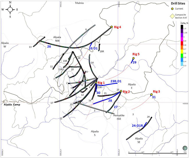
Very hard to see on the plan map in the press release, but fortunately with the power of Photoshop, we can lighten this image. I've chucked on my interpretations for fun.


The most consistent mineralization is around holes

Here is a zoomed in part of holes 15, 16 and 23 which is where holes 29, 29D1 are all heading, but that zone only has a 200m x 150m horizontal extents. The rest of the high-grade is quite scattered and look to be dikes.

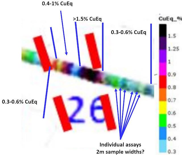
horizontal distance between the 2 lines = 35m


We can see the individual assays, they are a bit blurry as I've zoomed in really close, but you can see the individual assays and you can see how quickly the grade drops off around the high-grade samples.

Look at the plan map, how when you look closely, most of the >1% CuEq mineralization is restricted to narrow zones, that are hard to join together. there doesn't appear to be a solid, high-grade core, just a lot of narrow high-grade dykes surrounded by mineralization that would be marginal if exposed at surface, but at >500m depths, it will never be touched.

I'm a bit disappointed, and gut feel is that the actual resource will be significantly lower than what the market expects, as these high-grade zones aren't consistent and don;t appear to join up.

However, I invested in SolGold for the other targets, I knew that Alpala was deep and probably not good enough as a standalone deposit. I want to see them drill somewhere else.

If you want the full Leapfrog project - e-mail me at theangrygeologist@gmail.com and I'll upload it for you


Tuesday, October 3, 2017

AntaKori - the results continue.....

We got some more drill results from Regulus (link), you can download the Leapfrog viewer file here (link).

Summary:

  • Arsenic is controlled by the High-Sulfidation event, the skarn mineralization appears to contain significantly lower As.
  • Hole AK-17-002 was OK
    • Upper interval was similar to the 2012 resource grade (0.36 g/t Au and 0.48% Cu (link))
    • Lower interval - deep and low grade (less than 0.5% Cu Eq at ~400m vertical depth isn't special)
  • Hole DHSF17-160 - a very interesting hole, 
    • Decent, thick intercept of good grades, especially the lower Skarn mineralization
    • Hole located in corner of Regulus Concessions. This could mean the best mineralization is off their ground.
Here they are:

table 1

table 2


I applaud Regulus for including the second table, with Arsenic (As) assays. This is a project with "As issues", so why don't we look at the data a bit more closely.

If we split the assays by mineralization type - High Sulfidation (HS) and Skarn, we can see that the HS mineralization contains much more As than the Skarn.


parts per million (ppm) Arsenic
We see similar patterns with copper and gold.


The high sulfidation event is introducing additional metals into the system or re-mobilization them.

The good news, the Skarn contains significantly lower As content than the HS mineralization, but are lower grade.

So, if there is a big skarn at AntaKori, As shouldn't be a problem.

Drill-results

Let us look at the drilling data in more detail.

Hole AK-17-002

Overall, I was a bit disappointed in this hole. We can split the mineralization into 2 zones.

  1. Upper Zone - the High Sulfidation system - nothing special, average grade dragged up by a high-grade breccia, the rest of the zone was a bit underwhelming, especially as hole SDH-037 hit 188.55m @ 1.07 g/t Au and 2.02% Cu was only ~80m away.
  2. Lower Zone - the Skarn zone - generally a bit crap, it was poorly mineralized (less than 0.25% Cu) and deep. 
Au

Cu


Hole DHSF17-160

This was much more interesting. A good, thick, decent grade skarn drilled where no skarn has been drilled before....

Some nice thick >0.5% Cu with a nice gold bonus. the drill-holes around it didn't hit anything.

Au


Cu


There is very little historic drilling in this area, and it suggests that potentially the core of the skarn mineralization could be located between holes DHSF-17-160 and 161, but this is where we start to run into the boundary problem, it suggests that the core (best?) part of the system is located on Coimolache concessions...


So, it will be interesting to see the results from holes AK-17-003 and DHSF17-161