Tuesday, December 26, 2017

Nickel Mountain - data redux

Fortunately Garibaldi haven't released any data from the remaining 4 holes (EL-17-10 to 13), so I was bored and compiled some of the old data for fun (excluding trenches).

Here is an updated Leapfrog Viewer file (link) with the Garibaldi and historic drilling data.

I've also brought in the historic surface geology maps, the referencing is a bit off as the old maps are in imperial units, but they are close enough to match.

Here is the Garibaldi Figure 1 - Plan Geological map, that isn't on the website, but was sent to me.

Yellow line = trace of hole EL-17-14
I'm not disclosing any non-public information, as the map that GGI are using is just a digitized version of the scanned, hand-drawn 1965 geology map.


And both, GGI map superimposed on the 1965 map

Snap!

So, have Garibaldi done any surface mapping or just geophysics and drilling?

A rhetorical question...

A quick section

Drilling below red b;obs = Exploration Success!!
We can see that all GGI have done is:

  1. Drilled below the historic holes to check for the continuation of Ni-Cu mineralization
  2. Drilled a few holes into the other sulfide zones mapped in 1965.
So, nothing clever here, and I'm surprised that in reality, such little work has been done outside of EM (again, we don't have any usable amps from this program) and drilling.

anyway, I look forward to receiving the results from holes 10-13, these results are a couple of weeks overdue. It only took GGI 19 days to get the results for hole 14, so I'm guessing that hole 10 would have been completed a month earlier.


Monday, December 18, 2017

Regulus - Antakori update

Just a quick update, a couple of weeks ago some additional assays were released by Regulus from Antakori (link).

Summary


  • Drilling restricted to the edge of the property
    • Focus on HS-epithermal system by Coimolache - drilling to extend pit resources
    • It is going to be interesting to see some drilling in 2018 designed by Regulus
  • Arsenic restricted to the Intermediate Volcanics and the HS-epithermal mineralization.
    • Minimal As in Skarn zone.
  • Thick, but relatively low-grade Cu mineralization hit by hole 17-161 extends the limits of the Skarn mineralization by 400m to the SE, but the elevated Zn and decreasing Cu indicates that it was drilled near the edge of the system.
I've brought in the new data into 3D and run it through Corebox's Drill Hole Interval calculator, and built a 3D model, that you can download it from here (link - note: it is 63MB in size). I want to see how the Cu, As and As are related.

DISCLOSURE: I have used the assay information from Table 2 as it includes assays for Ag, Zn and As. Its intervals are slightly different to Table 1, from where the press release headline was is referencing, so there will be slight differences.

Geology

We can see that all the 2017 drill-holes have come from around the SW margin of Regulus' concessions. When we overlay this information onto a satellite image we can clearly see that the drilling by Coimolache is focused on drilling the extensions of the High-Sulfidation (HS) epithermal mineralization that they are currently mining.

Black = 2017 Drill-holes
Results are focused along the SW margin of the Antakori concessions, it looks like Coimolache are focusing on drilling the extensions of mineralization currently being mined.

Here are a series of sections from the latest results.

Section - L1050NW - Drill-hole AK-17-003 and 003A

Copper


We can see that the highest copper grades (>0.25%) appear to be found at the contact between the HS-epithermal (in the Light-green Upper Volcanics) and the skarn mineralization (in the Light Blue limestones), and are the discrete >0.25% Cu zones restricted to the narrow, intrusive dykes (pink and red units)?

Gold


It appears that all the gold mineralization is found in the upper HS-epithermal zone. Minimal gold appears to be found in the intrusive rocks).

Arsenic


Here we see As is restricted to the upper HS-epithermal zone with minimal As in the Skarn.

Section - L200NW - Drill-hole DHSF17-161 and AK_17_004 (results pending)

Copper

Again, Cu is restricted to the Skarn (limestones). It is generally low grade, around 0.1 to 0.25% Cu, but there are a couple of narrow, high-grade (>1%) zones that appear to be associated with either the old breccias or narrow Young Felsic units. In the NE, several short holes have intersected narrow Cu-Au mineralization associated with narrow, massive sulfide veins.

Gold

Minimal gold was intersected by hole 17-161, this hole didn't intersect HS-style mineralization within the AK concessions. It will be interesting to see how much HS-mineralization will be hit by hole  AK_17_004.

Arsenic


Again, minimal As is found within the skarn units.


So you can see that the Cu grades are gradually decreasing to the SE, and the elevated zinc assays seems to indicate that hole 17_161 was drilled into the peripheral part of the large Antakori skarn system, suggesting that the high-grade core is probably located to the NW.


Wednesday, December 13, 2017

Timok - the Lower zone

Some updates to correct for some inaccuracies, and to update the resource table to include additional information.

And now for something completely different...

I wasn't expecting the Spanish Inquisition over Nickel Mountain.


Back to reality, Nevsun have been releasing some great results from the Lower Timok Zone (link), we can see on the accompanying plan maps and sections that this zone is large, but deep.

Figure 1 - The Plan Map

You can clearly see the footprint of the Lower Zone, with approximate dimensions of 1.5km wide by ~1km. To the south, we can see the smaller, but very high-grade Upper Zone.

Figure 2: The Section....
So we can see that the Lower zone extends from 800m to ~2000m below surface. I've added some annotations.

Figure 3: The horse chestnut---hurrah!

We can see that there is potential to extend the known mineralization to depth, and maybe to the West, where no deep drilling appear to have has occurred beneath the Upper Zone.

However, I commented in previous posts that one of the problems at Alpala was its depth. The initial drilling didn't appear to outline a resource that was sufficiently large or high grade to support the development of a stand alone, large-scale, underground operation. Do we have the same issues at Lower Timok?

I've compiled as much data that I can find for Lower Timok, and I've also included the recent (2016-17) drilling from the high-grade Upper Zone as well, just to allow you to compare their location, depths and relative sizes.

You can download the 3D viewer file from here (link).

The first step was to evaluate the size and grade for the Lower Zone. I created a series of grade shells for Au, Cu and CuEq (I used Nevsun's CuEq calculation 1g/t = 0.7% Cu). These are all included in the Leapfrog viewer file as well as all the sections from the December 4th PR.

Disclosure:

  • I haven't factored in any recoveries for Au and Cu when calculating the CuEq values
  • I have not been able to find any assays for holes TC150073 and TC160073B
    • These holes go through the center of the Lower Zone, and therefore my Bad Estimates (TM) are likely to be slightly low. I'll keep looking for this data,and when I find it, i'll update the model.

Here are the assumptions I used to create the grade shells in Leapfrog Geo:
  • Base range = 400m - the holes are widely spaced (they may even be too wide to determine an initial inferred resource)
  • Interpolant = Spheroidal
  • Drift = None
  • Specific Gravity = 2.7 (assuming the rocks are granitic in composition with minor sulfides)
  • I applied a filter so that the Upper Zone drill-holes would not be used to create the various grade shells.
Here is an updated "officially bad estimates" (TM) for the Lower Zone:


Just a couple of observations:
  • There appears to be a lot of contained metal at Lower Timok, 
    • the majority is too low grade for an underground operation and should be considered as 'mathematical' resources.
  • The overall gold content is low
    • Will the concentrates contain payable amounts of gold?
At the bottom of each table I've given a tonnage and grade at various cut-off limits. I'm going to use a 1% CuEq in the following section.

If we compare my 'resource' CuEq grades and plot them against the Macquarie Reseach report on large-scale underground porphyry projects.


Red dashed line = average grade for Lower Timok (using a 1% CuEq cut-off) = 1.28% CuEq
Blue star = cut-off value for a underground block cave operation for a brownfield operation
Green star = cut-off value for a greenfield block cave operation


Lower Timok grade vs other Block cave operations/development projects 
We can see that Lower Timok isn't quite good as a stand alone greenfield development project, but as it is adjacent to Upper Timok, with a quite robust PEA, we can considered Lower Timok to be a brownfield project, and now we see that it is high enough grade to pass the Brownfield hurdle grade.

However it isn't quite as simple as that. If we look at the recently released PEA from the Upper zone (link), and we are told:

  • Initial Capex ~$US615M
  • Mine Life ~15 yeears
  • Mining rate ~8,900 tonnes per day
  • NAV = $1.5B
If we compare this to Stage 1 for Wafi-Golpu project (link), which I think could be a good analogue to the hypothetical costs to develop Lower Timok.


You can see that I've highlighted some important values.

  • Initial Capex = US$2.6B
  • Ore mined and milled = 149Mt (approximately similar to Lower Timok)
  • Mine life = 28 years or approximately 15,000 tonnes per day
  • First ore milled = project development time line = 60 months or 5 years
  • Steady-state production = time taken to reach full capacity = 90 months or 7.5 years

So, if Nevsun were looking to develop the and mine the Lower Zone, it will require significant additional CAPEX, larger milling and surface facilities (tailings and waste dumps) than proposed for the Upper Zone mine. This means that Lower Zone is a half-greenfield half-brownfield project - I'll call it an Olive Project, and that Nevsun have a couple of options:

  1. Mine the Upper Zone, make lots of money and 'keep' the lower zone on their books as a large resource, but don't develop it.
  2. Mine the Upper Zone, and after 5 years start the permitting and development of the Lower Zone, and slowly increase the size of the surface facilities (Mill, tailings, waste dumps etc.), and bring the Lower Zone into production towards the end of mining the Upper Zone.

This is my hypothetical scenario for Lower Timok

  • Initial Capex = US$1.5B (the topography is significantly easier around Timok so less earth moving, and assuming that they will use and expand on the Upper Timok surface facilities)
  • Ore mined and milled = 200Mt
  • Mining rate = ~15,000 tonnes per day
    • Need to expand surface milling facilities by 5000-6000 tonnes per day
    • Expand the flotation circuits
      • I don't know how feasible this is, but it is something that Nevsun may need to consider to include as part of the development of the Upper Timok project, especially permits for expansion of tailings facilities as these may taken several years to obtain.
  • Development period = 3-5 years
  • Time taken to reach full capacity = 5-7 years (including development period).
    • The idea is that the project would need to be developed while the Upper Zone is being mined and then Nevsun can extend the infrastructure from the Upper Zone development into the Lower Zone.
At the moment, there aren't a huge number of drill-holes into Lower Timok, and the drill hole density is still quite low (approx. 300-400m between drill-holes), but the initial data shows a robust porphyry system, that is open in a number of directions.

The initial (i.e. very bad) review suggests that it could support a medium-sized underground operation, but its development is dependent on the economics of the Upper Zone and how Nevsun/Freeport decide to develop the Lower Zone.

Will Nevsun just focus on the Upper Zone or will they factor in the development of the Lower Zone into their future decisions for the project? 

For investors, the upside could be, that if the Lower zones becomes significantly larger (e.g.>500Mt at similar CuEq grades), would Freeport step in and take out Nevsun to consolidate their ownership of a large porphyry Cu-Au deposit not owned by a major mining company?


Saturday, December 9, 2017

Garibaldi - Mighty Massive Sulfides - The Return

We got the results from hole EL-17-14 today (link).

Summary:


  • Hole EL-17-14 assays are high-grade, but drilled down the guts of the Discovery Zone
  • Drilling still restricted to a 50m wide section, so 3D orientation of massive sulfide zones are hard to determine accurately.
  • However, the drilling to date indicates that the massive sulfide bodies are quite small, but most ore open in several directions suggesting potential to add, albeit limited, tonnages.

Pro-trick for Garibaldi - if you are going to put a table in your press release, don't include a sub-interval that is lower grade, it just shows that you are smearing a very high grade zone over the thickest interval possible.


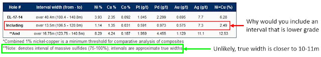
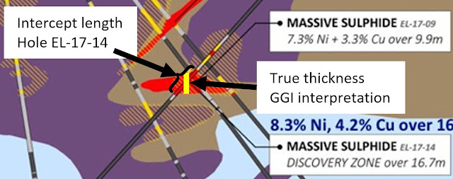
It is also obvious that this intercept is not close to true widths as suggested below the table, but it shows that Garibaldi thought that the Discovery Zone was parallel to the upper sulfide zone intersected by holes EL-17-04 and 09 and dipping approximately to the NW.

this is their own interpretation from all of the data
This means that hole EL-17-14 was orientated to drill down the guts of the Discovery zone to try and get as long an intercept as possible, so here is my very simple interpretation, based on the intercepts in holes EL-17-14 and EL-17-09.

10.63m is almost 16.75 meters?
It looks like the Discovery zone is ~10-11m thick, based on the >2% Ni assays and reported massive sulfide mineralization.. This is significantly less than the 16.75m than Garibaldi are suggesting in the notes beneath the assay table.

I've brought the data from hole EL-17-14 into Leapfrog and created a new model (link), I've also done some officially bad mineralized material calculations (TM) to get an idea of the size and potential at Nickel Mountain, to see how GGI can justify a ~CND320m market cap.

Add caption
Here are my assumptions:

  • Search distance = 50 m, 
  • Specific Gravity - I've used an increasing value based on grade, using densities from Sudbury as a base (Note - SGs at the Eagle deposit average 4.44 t/m3)
    • >0.5% Ni = 3 t/m3
    • >1% Ni = 3.5 t/m3
    • >2% Ni = 4 t/m3
  • There is no specific orientation on mineralization - as all drilling to date is restricted to 50m wide plane.
If we compare Nickel Mountain, with the best-est-ist grades in the wurld, to the Eagle Deposit.
Eagle, Dec 2016 Reserves (Lundin Mining)
Eagle was acquired by Lundin Mining in 2013 for US$325M (link) or CND$416 (at current exchange rates), which is only CND$100m more than Garibaldi's current market cap.

Why? There are only 14 holes drilled at Nickel Mountain, no resources, and the massive sulfides appear to be narrow, and inconsistent. Before you hurl abuse at me, just take a step back and ask yourself - what does GGI have to warrant such a high valuation?

I also can't see the upside potential, and I don't like that GGI have been very poor at releasing quality data for the project (you could think there is a reason for this). We still have no plan maps, no geophysical sections, no presentations etc. This isn't something you would expect from professionals running a professional company.

Simply put - Nickel Mountain, Es Mundus Excrementi!

Boring Geology Bit


I've also included some scenes showing my interpretation of the various sulfide zones and their orientations that I can determine from the limited data available. I've split it into 4 separate zones, as I was intrigued by this statement.


Here are the various massive sulfide zones, I've decided to label them, as Garibaldi can't.


Using the data provided, I've created a series of estimated trends for each zone.


To create these trends I lined up the various massive sulfide/high-grade zones in 3D. It was fortunate that Garibaldi don't label these zones on their cross section or in the drill intercept tables.

I apologize to any non-technical readers, the following section is going to be full of geo-wank. I've included some features on the sections through each zone:
  1. Colors - the Zn grade shells on the section line
  2. Black line = 25m distance contour from each drill-hole
  3. Grey line = 50m distance contour
The distance contours show me where drilling has and hasn't occurred and is useful to identify areas that have and have not been drilled.

Discovery Zone

This is the zone that Garibaldi have been getting erections over, discovered by hole 09, but only recognized 5 holes later.

This zone appears to be almost horizontal, intersected by holes EL-17-02, 04, 09 and 14, but only holes 09 and 14 hit significant sulfides and mineralization.


We can see that hole 09 and 14 are just 20m apart, and the entire zone is only 60m wide, and closed off to the NW by hole EL-17-02 and to the SE by hole EL-17-04. However, it is undrilled to the NE and SW. For me it will be interesting to see if holes 10-13 explore this zone.

Upper Discovery Zone

This zone was defined by holes EL-17-04 and 09. It dips, relatively steeply to the west and is quite narrow (2-5m). 

biggus dickus
Drill-hole EL-17-02 has closed off this zone to the northwest. Hole EL-17-14, 100m to the east, and EL-17-01 ~50m to the west didn't hit anything, again suggesting this zone is quite small, but with expansion potential.

Northwest

This zone has been well drilled, it sits above the Historic Zone and appears to be steeply dipping to the SE.

Note: this section is orientated with north to the right.

So this zone is closed off to the south (left) with the drilling intercepting narrow >1% Ni zones. However, it is open to the North (right), with hole EL-17-08 intersecting ~6m of massive sulfide mineralization, so again, there is potential to expand this zone with additional drilling.

Historic

This is where exploration occurred in the 1960s. It has been well drilled by Garibaldi. To date 6 holes have drilled through this zone, but only 2, EL-17-03 and 07, have returned decent grades. It is closed off to the west by holes EL-17-05 and 06 that were unmineralized. To the north by hole EL-17-08 (unmineralized), and to the west by hole EL-17-01 that cut disseminated mineralization.

However, there is minor potential for this zone to continue to the NE, but the drilling by Garibaldi show that it is very small


So, all I can see is that the sulfides are small, have very variable thicknesses and grades over very short distances, but each zone is open in 1 or more directions. It will be interesting to see where holes 10-13 are located (I'm surprised that they were not able to release the assays from these holes as they were all drilled before hole 14 - could there be a reason - i.e. they are shite), if they are in the same Section, then, for me it just means that even Garibaldi knows that they are small and focusing on this small zone as it is the only area with evidence for massive sulfide mineralization. 

Wednesday, December 6, 2017

Garibaldi Update

Garibaldi have released more drill-hole data from the Nickel Mountain (link).

I've updated the 3D viewer file, and you can get it from here (link).

Summary


  • Very closely spaced drilling has intersected 4 separate massive sulfide lenses
  • Massive sulfide mineralization appears to be small and inconsistent.


Here is a plan map:

Ni at top; Cu below


We can see that the drilling has focused on just 2 small areas, and explored mineralization for just 25m along strike:

  • Central and Northwest Zones - This is where historic drilling identified massive sulfides and Garibaldi have drilled 6 holes (01, 03, 05, 06, 07 and 08) into this area
  • Discovery Zone - explored by 4 holes (02, 04, 09 and 14*).

*assay results pending

The drilling appears to have identified 4 separate, narrow massive sulfide zones, but they appear to be small, and discontinuous.


Northwest and Central Zones

Let us look beyond the assays and at the actual intercept locations.

Yellow > 1% Ni, Red >2% Ni
Drilling in this area has identified 2 separate massive sulfide lenses, the lower NW zone and the upper Central zone. However, even though Garibaldi have drilled 6 holes drilled into this area, only 2 holes hit massive sulfide mineralization for each zone.

  • NW Zone - intersected by holes EL-17-06 & 08
  • Central Zone - intersected by holes EL-17-03 & 07

This seems to suggest that the massive sulfide mineralization is very inconsistent and poddy.

Discovery Zone

Garibaldi have drilled a lot of holes into a small area and again defined 2 separate massive sulfide zones, the lower Discovery Zone, and an narrow upper zone.


Red >2% Ni; Black = Hole 14 MS zone

We can also see that drill-hole EL-17-02, drilled ~30m down-dip from both zones hit no massive sulfide mineralization, which again suggest that the massive sulfides are small and inconsistent.


Red >2% Ni; Black = Hole 14 MS zone

Some nitpicking


We got told this in the Nov 20th PR (link), hole EL-17-14 discovered a 'new' massive sulfide zone - the Discovery Zone.


However, In the latest PR, we are told:


Surely hole 09 was the discovery hole as it was drilled first.


We were also given a updated section (but no plan map), but what I find strange is that Garibaldi completed drilling at Nickel Mountain in mid/late-November.

Left = Nov 27th PR section; Right = December 06 PR section
As we have the DH data, we know that 10 holes are located on this section (EL-17-01 to 09, and 14), so why didn't Garibaldi include the drill-holes traces and massive sulfide zones on the original section map released to the public (at the request of the BCSC) on the 27th of December?

It just seem strange that Garibaldi would not include useful information, including an additional massive sulfide zone on the original section? All they had to do was include a few labels stating "Massive sulfide zone - assay results pending" and that would have been OK.


Also in the Nov 20th PR, we have this paragraph.


Does this mean:

  1. Garibaldi have only drilled 10 holes at Nickel Mountain, and were unable to drill holes 10, 11, 12 and 13 due to poor weather conditions?
  2. Garibaldi drilled 14 holes, but in the November 20th PR, they were waiting for the results from the final 10 holes? This means that they were sitting on the assay results from 4 holes.

Silly me, Garibaldi included this paragraph in the Nov 20th PR


So, they were sitting on the assay results from 4 holes, so why didn't they release it?


Thursday, November 30, 2017

Garibaldi - BCSC to the rescue

Christmas has come early, thanks to the BCSC not being happy with the disclosure in the original Nov 20th PR (link), Garibaldi, issued a new press releases clarifying the information from the first 4 drill-holes at Nickel Mountain (link).

Summary


  • High-grade mineralization restricted to narrow zones
  • Massive Sulfide zones are very narrow, maximum thickness 1.5m (Hole EL-17-03)
  • Discovery Zone Massive Sulfides - appears to be a small pod, adjacent holes didn't intersect it.


We get a table with hole locations and a breakdown of the assays!

Massive sulfide intervals highlight in red

I've highlighted the massive sulfide intervals (** in the press release table). However, in the Nov 20th PR, we are told that:


In the table, this isn't labelled as a massive sulfide zone, is this just a typo? I'm splitting hairs, but we often see in other deposits we often see S.H.I.T. intervals related to veinlets/pods of mineralization.

We are still missing a decent plan map, but with the information provided I've brought the data into 3D (get the viewer file* from here - link), and due to my prodigious use of a ruler, I've also added the EL-17-14 discovery zone as as well.

*you'll need to download the latest version of Leapfrog viewer (4.1) from here (link)

Plan View

1 square = 50m

There are a lot of holes in a small area, and the Discovery Zone is very close to the narrow Ni-Cu intercepts in holes EL-17-02 and 04.

Section View

Nickel


EL-17-14 sulfide zone is Black

Copper


EL-17-14 sulfide zone in black

Again we see that the Discovery sulfide body is surrounded by drill-holes. Does this mean that it is very small?


The Discovery zone is only 32m from hole EL-17-04 and 27m from EL-17-02. However, it isn't completely close off, there is potential to expand it to the north and east, unlike the other zones where adjacent holes hit virtually nothing.

I'll be updating the model with more data as if it is released.


Tuesday, November 28, 2017

Garibaldi - mighty massive sulfide mineralization

I might as well jump onto the Garibaldi-bashing wagon. I had stood on the edge muttering to myself, how the feck are were they worth >$400M based on feck all?

Their website is shite, devoid of information and looks like it was created by a child, probably the same one who created the 'fact sheet', but at last we got a section through the Nickel Mountain, the first decent 'image' from the project....ever (link)

It is a shame that it wasn't accompanied by a plan map, which would be useful in showing the 14 Garibaldi holes and the location of the 1960s drilling?

When looking at a map/section - start with the basics
  1. Scale - look to see if there is a grid or scale bar.
    • Quickly see how far apart the holes are located (50-100m)
    • How 'big' the massive sulfides are 
  2. Legend - this tells you the colors used for grades and rock types
    • check out the dark grey = no assay = Nothing of interest (i.e. no sulfides) in the core
  3. How consistent is the mineralization - does it link up between adjacent holes?
    • No, we get a few scratchy hits, with a small disseminated halo.
You need to ask yourself, can I, armed with a mighty No. 2 pencil (HB in the normal parts of the world), join the zones together?

here is an easy one for Garibaldi to do
I'm not an expert on Nickel deposits, but I've decided to annotate it, to highlight some interesting features and I've made a few observations.


So, how big are our massive sulfides?

They are soooooooo massive, that each one has just been hit 1 hole. Approximate dimensions:

  1. Big Boi - reamed by hole EL17-14 = 29m x 12m
  2. Old MoFo - penetrated by hole EL-17-03 = 2m x 91m
  3. Skinny Man - pricked by hole EL17-04 = 5m x 50m

So we have 3 small, inconsistent massive sulfide bodies, with minor disseminated sulfide halos.

So, after a disappointing press release, how can you save face, well, we needs to ask the FAG.

Hello FAG* here, I was disappointed that Garibaldi were defeated by unseasonable Northern Canadian weather. Who would have thought that they would have had snow this time of year in the Polar Riviera.

(*Fraudulent Angry Geologist)

I was very disappointed with Garibaldi's program, a true professional would have moved holes EL17-01 approx. 20m to the left, that would have hit >100m of disseminated sulfides, but they redeemed themselves with Hole EL17-14. So, if you are a company like Garibaldi, dedicated to not releasing any useful information, my advice is, have some fun, and really do to town on the drilling. Here is my idea:

Proposed holes in GREEN
Those 4 holes are beauts, multiple sulfide hits and nice and easy. OK, you're drilling the same areas 2-3 times, but we are searching for 'geological continuity' not drilling for resources. Chuck in a few words like, structural complexity, offsets and everyone will be happy and you'll get some decent hits to keep the shareholders happy.

If those dipshit geologists keep bleating, remember that with all that cash you raised, you can keep giving yourself a huge salary for the next 3-4 years, which is a happy thought.

Just a note to Dorian Leslie - your maps are great.

SolGold: regional exploration

DISCLOSURE: I own shares in SolGold 

In between PRs about awesome drill results we got this one (link) showing some results from their regional exploration on their Machos-Florida Santa Cruz-La Hueca concessions in Southern Ecuador.

Dear SolGold - the La Alumbrera Mine is Miocene in age (~7Ma), not Jurassic (145-201Ma). So they don't get any cool dinosaurs (e.g. Chilesaurus (link), just Terror Birds, and check your scale bars, they are wrong.


Summary


  • Good address - large property package located in the Jurassic porphyry/epithermal belt in Southern Ecuador (Mirador and FDN)
  • Good initial results - Regional sampling has identified 3 areas of interest
  • Follow-up rock-chip sampling identified an initial area with good indications of porphyry mineralization.
So it is early days, but SolGold have hit the ground hard, applied a logical exploration strategy when working on a large property. Start big, do regional sampling to identify areas of interest, and then focus on them.

Location, location, location

As I've mentioned before, porphyry/epithermal deposits occur along belts, and in Ecuador there are 2 principal belts:

  1. Older Jurassic Belt - hosts Fruta del Norte (14Moz Au) and Mirador (890Mt @ 0.56% Cu and 0.16 g/t Au)
  2. Younger Miocene Belt - hosts Cascabel, Junin etc.


So, if you are looking for these types of deposits, these areas are where you want to be, and SolGold's concessions are located in the Jurassic belt. They have acquired a large property (~25km x 10km), and unlike many exploration companies, have actually conducted a logical exploration program to quickly evaluate the property and identify areas of interest for follow-up work.


Stream sediment sampling

This is used to quickly evaluate large areas to identify areas of interest for follow-up with more detailed sampling. The idea is that if a deposit is exposed at surface, it will be eroded and indicator minerals (gold, magnetite etc.) will go into the silt, sand and clay in a stream or river bed.

Each one of these horrendously colored polygons is a drainage basin
SolGold have collected 180 stream sediment samples, probably 1-2 per basin, that have identified 3 principal Areas of Interest (AOIs).

2 small and a biggie, the red outlines are highlighting core areas (I think)
Just from collecting 180 samples, we can see that >80% of the property appears to have a low potential to host porphyry Cu-Au mineralization. This probably costs SolGold ~ US$20K, and has identified 3 areas of interest where more detailed (i.e. more expensive, more time consuming) exploration can be conducted.

The key is to identify areas with potential and not get distracted by the areas without. This is very unfashionable as a typical Junior exploration company will simply amalgamate concessions and do nothing with them.

Prospecting and sampling

After you have defined your AOIs, now you have to visit them to see what you've got, and it is this basic prospecting (i.e. looking for evidence for mineralization) that we are given in this PR.

Now, before you all go weak at the knees at the assays and photos, let's take a step back. SolGold have told us that they have ~470 rock chip samples, but this PR is only giving us info from just 46 samples (~10%), why? Are these:

  • The greatest hits?
  • The 1st batch, with more results to come?
It is obviously the former, figure 3 in the PR tells us that in the other areas they sampled disseminated chalcopyrite with low grade copper gold mineralization. 

We are also told that there is biotite alteration, this is typically found in the (potassic) core of a porphyry system, and it can be a bit of a double-edge sword, as this is where you typically get the highest grades. This is also characterized by the presence of bornite. However, if the samples collected from this area are not very high-grade, is this an indication that the porphyries are not well mineralized? This is a rhetorical question as it can only be answered by the truth machine (the drill-rig).

 mineralization, but if these samples aren't very high-grade, this may indicate that the mineralization 

We can also see where these samples have come from, they are shown on the map above, but why don't we zoom in a bit. 

Left = Copper; right = Gold, the red circle is 1.2 km wide
We see a cluster of samples, some nice high-grade ones, but the majority are low grade, which isn't unexpected at this stage.You also have to remember that most rock-chip sampling is biased, the pretty rocks get sampled first, so they aren't really representative of the overall grade of the rocks.

So it is a good start from SolGold, they have identified an interesting target with decent initial results. At this stage all you should be reading into this press release is that SolGold have found evidence for porphyry-style copper gold mineralization on their new concessions. It is a good start and I hope to see more information from SolGold on their regional exploration activities.